
About Us
Budalangi Constituency
Topography
• Budalangi constituency is number 231 of 290 constituencies in Kenya according to Independent Electoral Commission (IEBC). Budalangi constituency was created in 1966 as Busia South (c/no 135) after the larger Ruambwa (c/no. 87) was split into two. The other part became Busia Central (c/no 134). It was renamed Bunyala (c/no.159) in 1987 and renamed again in 1996 to become Budalangi (c/no 178). It retained the same name and code number until 2012. When it became c/no 231.
• Budalangi constituency has a population of 66,723 that consists of 31,719 males and 35,004 females, with a population density of 354 persons per square kilometer. The main economic activities are farming and fishing. The constituency area has a great potential for irrigation projects and thus engages in rice farming in large scale through the popularly known Bunyala irrigation scheme in collaboration with the National Irrigation Board.
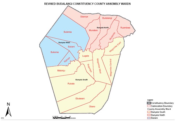
•Budalangi Constituency administrative ward is as below.
Health
The health sectors having been devolved has undergone tremendous positive transitions in Budalangi constituency, from increased number of health centers to low mortality rates
Budalangi constituency experiences various challenges in the provision of health care to its residents. Challenges such as affordable healthcare services, geographical barriers, shortage of healthcare providers among others. A major concern in health sector is the infant and under five mortality rates that is instigated by the high levels of poverty, diarrhea diseases , HIV/AIDS and TB. In addition, lack of skilled attendance at birth , delayed treatment and high costs incurred at hospitals are also key contributors to maternity mortality. The needs of the health sector in Budalangi can be summarized as follows:-
Need to construct health facilities in every sub-location
Need to equip the existing health facilities.
Need to sensitize the public on importance of NHIF cover
Need to roll out sensitization programs on importance of hand washing and using insecticides and mosquito nets
Recruitment and deployment of health workers
Need to train social health worker in every sub-location
Education Sector
The national Government through NGCDF promotes Education in government institutions in the constituency through various strategies. The overall objectives are to increase access to education and training, improve quality and relevance of education, reduce inequality as well as leverage on knowledge and skills in science, technology, and innovation for global competitiveness.
1. Upgrading of infrastructure in all primary, secondary and tertiary institutions in the constituency.
2. Profile all needy students who will require bursary
3. Encourage more active participation of parents on the development of schools.
4. Construction of laboratories and equipment to boost performance of science subjects.
Environment Sector
Floods are a recurrent environmental hazard and impede access to environmental resources and agricultural production. The physical setting of Budalangi at the flood plain of Nzoia River and increased run off from degraded catchments are contributory factors to the flooding. Floods lead to disruption of human settlements and destruction of crops, shelter , dykes and infrastructural facilities. Disease outbreak also increase due to the destruction of sanitation facilities and relocation of settlement in makeshift camps therefore there is need to
1. Construction of permanent dykes
2. Need to put measures of controlling sand harvesting
3. Need to enforce regulatory systems
4. Need to control and put policies and measures on forest degradation
5. Need to sensitize the public on effects of environmental degradation.
Access NG-CDF Information on your Mobile


County Assembly Wards in Budalangi Constituency :
Bunyala Central Ward
- County Assembly Ward No.:
- County Assembly Ward Name: Bunyala Central
- County Assembly Ward Population (Approx.): 10,381
- County Assembly Ward Area In Sq. Km (Approx.): 47.70
- County Assembly Ward Description: comprises part of Magombe East, Magombe Central, Magombe West
Bunyala North Ward
- County Assembly Ward No.:
- County Assembly Ward Name: Bunyala North
- County Assembly Ward Population (Approx.): 20,948
- County Assembly Ward Area In Sq. Km (Approx.): 57.20
- County Assembly Ward Description: comprises part of Sisenye, Budalangi, Mundere, Ruambwa and Mudembi
Bunyala West Ward
- County Assembly Ward No.:
- County Assembly Ward Name: Bunyala West
- County Assembly Ward Population (Approx.): 21,237
- County Assembly Ward Area In Sq. Km (Approx.): 26.50
- County Assembly Ward Description: comprises part of Bulemia , Bukani, Siginga and Bukoma
Bunyala south Ward
- County Assembly Ward No.:
- County Assembly Ward Name: Bunyala south
- County Assembly Ward Population (Approx.): 14,157
- County Assembly Ward Area In Sq. Km (Approx.): 56.90
- County Assembly Ward Description: comprises part of Mabinju, Rukala,Ebulwani, Obaro, Lugare and Rugunga